
Expected to open in phases between 2026 and 2033, HS2 will eventually link London, Birmingham, the East Midlands, Leeds and Manchester. However, eye-watering budget increases, forecasted damage to local communities and the project’s wonky timeline have led many to speculate it has gone wildly off track.
In the midst of the controversy, new state-of-the-art drones and cloud-based technologies could be one saving grace for HS2. SenSat is a London-based start-up that uses visual and spatial data to create digital replicas of the real world. In March 2018, it used data captured by autonomous flying drones to create digital topographical surveys of the upcoming HS2 route between London and Birmingham.
Go deeper with GlobalData

Discover B2B Marketing That Performs
Combine business intelligence and editorial excellence to reach engaged professionals across 36 leading media platforms.
James Dean, founder and CEO of SenSat, says this staggering project – the largest small unmanned air vehicle (SUAV) operation of its kind – was partly spurred by HS2’s struggles with finances and a bid to prove the ability of beyond visual line of sight (BVLOS) drones.
Using digital maps, the hope is that stakeholders in the rail project will be able to carry out survey, design and construction works more effectively, without treading on the toes of local landowners.
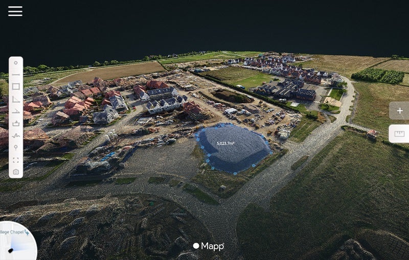
Mapping the HS2 route

Prior to the HS2 route capture, the rail industry was not on SenSat’s radar. However, the company’s extensive involvement in road infrastructure gave it a pedigree for mapping linear routes. In addition, its involvement in the UK Government’s Drone Pathfinder scheme allowed the company to fly SUAVs up to 12km away from their pilots – a far cry beyond the 500m limit stipulated in general regulations.
To map out the HS2 route, SenSat made use of fixed-wing autonomous drones – effectively miniature planes equipped with high-resolution cameras. These flew 80m above the ground, taking thousands upon thousands of pictures of the HS2 route below.
Across three weeks in March 2018, the drones flew more than 23km every day along pre-programmed autonomous routes. They collected a total of 18.2 billion measurement points, captured to an accuracy of between 30mm-50mm. These points were then stitched together to create full 3D digital maps of the Phase One route.
Because storing thousands of multiple-gigabyte files on a regular computer wasn’t possible, the dataset was propagated through SenSat’s cloud-based platform Mapp. This would allow HS2 contractors to access a full digital recreation of the route from their computer, giving them an accurate record of construction progress and facilitating enhanced data sharing. Dean says the result looks like a mix between Google Maps and the famed city simulation video game SimCity.
“Basically you can pretty much go and look at any stretch of that route,” he says. “You can see detail down to pretty much as small as a coke can in those datasets.”
Speeding up data capture

Previously, surveyors would be required to walk and climb over hazardous terrain using static 3D laser scanners, a task that would be dangerous, time-consuming and much more expensive.
“It’s not really apples for apples because you wouldn’t pay someone to go and achieve that fidelity and depth of information for the entire route,” says Dean. “If you did, it would probably cost tens of millions, but the cost savings are generally about 90% over the traditional means.”
Data capture can be anywhere between 400 and 3,000 times faster than manual methods depending on whether BVLOS drones are being used, says Dean, while also capturing more than 15,000 times as many measurements. The drones also removed the hassle of gaining access to land to carry out surveys – something that has plagued joint ventures involved in the HS2 project from the start.
The drone-captured data could have a variety of use cases; companies could use it to validate designs and compare ‘as-designed’ and ‘as-built’ structures without needing to pay for repeat surveys, as the drones can collect new information quickly and cheaply. The complex task of calculating the volume of earthworks at construction sites could also be carried out more effectively using drones.
Dean says SenSat has commercial relationships with three of the big four joint ventures involved with the HS2 construction, and that it has been ‘engaged’ on the next section of the route between Birmingham and Leeds.
Observing the curve of the earth

Mapping the HS2 route didn’t come without its challenges, one of which was handling the size of data for processing and storage purposes. Even trickier, due to the length of the route, SenSat had to factor the curvature of the earth into its digital replica. This involved an internal team working on Geographic Information Systems (GIS) to apply a correction to the data as it was generated.
“Everything over about 2km has got to have a z axis – so a high elevation error starts to be introduced,” says Dean.
Furthermore, coordination was required with airports and other stakeholders along the route to ensure the task was carried out safely. This involved manually checking for clashes between drone and commercial flights, as well as filing a notice to airmen with the aviation authorities.
The drones themselves could be manually overtaken at any stage and were fitted with real-time kinematic receivers, allowing them to be tracked to within 10-15mm of their current position.
The wider picture of the HS2 drone project
The UK Government’s Drone Pathfinder programme is exploring the potential of BVLOS drones across a number of sectors, with SenSat appointed the drone partner for infrastructure. The company is providing test data and feedback on potential policy changes regarding BVLOS before the UK Parliament makes a decision on them, which could happen in the early 2020s.
“The UK Government is really taking a centre stage in the world in terms of developing these regulations,” says Dean. “It’s been a really good collaboration between industry and the government regulator to achieve what we’ve done so far.”
Rail infrastructure owners, including Network Rail, are already exploring the use of drones in maintenance and survey operations. However, the HS2 project is a landmark case for their progression in the industry. Using non-BVLOS drones to survey the route would typically have required 470 individual drone flights, but the BVLOS drones can carry out the same thing in just seven.
Dean says that monitoring trackside vegetation is one example of a practice currently being carried out manually, but which could be made considerably faster with drones. “Because you have digital datasets you can actually begin to automate the detection of those kinds of things,” he says.
In the meantime, SenSat hope to create a ‘simulated reality’ system, whereby 3D digital replicas of the physical environment could be embedded with real-time information, such as the location of workers.
When it comes to the HS2 project, Dean says that its future is looking “a little bit rocky right now”, and that throwing more money at it won’t necessarily lead to better infrastructure. However, introducing new technology – to reduce costs in the long term – is a different story.
“There’s no massive incentive at the contractor level to push technology, because the way that they get remunerated is not by making things cheaper in most cases – especially on the profit margins they operate,” he says. “So it is really up to the government to start to mandate these things.”
“I don’t know which way it’s going to go, but I know if we do go ahead, we need to adopt technology to make sure it’s successful.”
