

In 2012/2013 alone – the second wettest year on record – around £136m was paid to train operators in respect of unexpected cancellations and delays, with similar scenes of disruption and travel chaos seen again the following year, as England and Wales suffered their wettest December to January since 1876.
Go deeper with GlobalData

Discover B2B Marketing That Performs
Combine business intelligence and editorial excellence to reach engaged professionals across 36 leading media platforms.
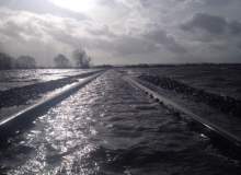
Between heavy rainfall, storm surges and coastal inundation, flooding poses a persistent problem for Britain’s vulnerable rail system but, thanks to a new project by the University of Cranfield, it may soon be one that will give Network Rail fewer headaches over the coming years, whatever the weather does.
Cranfield project
"Last year we sponsored a small MSc group project at the University of Cranfield. The aim of the project was to understand whether we can use any of our historical data on flooding incidents and the data we collect in our Asset Information department to help support Network Rail in its wider response to flooding," says Jon Drea, the company’s head of Analysis and Reporting.
The project set out to evaluate the existing data analysis methods and flood models to identify techniques applicable to Network Rail, develop one or more data driven approaches for flood risk modelling and implement the approach within a geographic information systems (GIS) framework.
"We asked the University of Cranfield to take a data-driven approach, rather than a more scientific approach because this fits with the core purpose of our Asset Information department," Drea says.
CART analysis
Combining Network Rail’s own accumulated data with a range of other factors, including meteorology, land use, surface run-off and soil hydrology, the Cranfield researchers developed a model using the Classification and Regression Tree (CART) technique of analysis to manage the different inputs. In addition, a web portal and 3-D visualisation system was also created to help rail engineers make full use of the model’s output.
Overcrowding on London’s rail network is not a new problem, but the stakes are high and new capacity is urgently required.
According to project leader Dr Stephen Hallett, the integrated flood risk assessment methodology that the team developed has the potential to be extended both beyond the initial case study areas and also to other types of events, such as landslips or embankment failures.
Flooding problems
If that promise can ultimately be realised, then it will be very good news for Britain’s rail network – much of which sits in cuttings or tunnels that are below the surrounding ground level, or in low-lying, flat areas where natural drainage is limited. This obviously makes them susceptible to flooding, and all the problems that brings. Point machines and signalling equipment can fail if water enters them. When flood waters rise too high, speed restrictions may become necessary, with electrified lines having their own problems as live conductor rails potentially short-circuit, while surging flood water can sweep away the supporting ballast beneath the sleepers.
Even where the water itself does not impact directly on the tracks, in many areas the additional weight in heavily saturated soil can result in significant land-slippage. This typically means delays as services are re-routed, and in some cases it can even lead to derailment. Harnessing the ability of the Cranfield model to help predict where such events may occur and how severely they will occur, brings obvious benefits to Network Rail’s operational management and dovetails well into other measures that are already being successfully used to mitigate the effect of landslips and flooding.
Risk mitigation
Part of those measures involves identifying those areas which are most at risk, using a number of means including, in the case of potential land-slip sites, helicopters equipped with laser imaging, detection and ranging equipment, and then managing them accordingly.
At locations with a particularly high risk, that may mean installing motion sensors and CCTV systems to monitor ground movement, which automatically trigger an alert and stop trains until an inspection can be carried out. In others, it may amount to nothing more complex than ensuring that ditches and culverts are clear of branches and leaves.
Effective response
Effective response is another key element in Network Rail’s flood management strategy. In the immediate face of weather and flood warnings, a range of flood defence systems are available for deployment, including the kinds of inflatable berms and modular ridged barriers often seen in the media coverage of last winter’s disruption.
In the longer term, pumping stations are being built in flood-prone areas to enable water to be moved quickly, and when lines that are at risk are renewed, both tracks and signalling equipment are being raised. Looking further ahead, Network Rail is taking steps to help avoid problems from developing in the future. High on the list is reviewing the proposed drainage arrangements on planning applications for developments near railways, and working in close cooperation with the Environment Agency, Flood Forecasting Centre and relevant local authorities to ensure the activities on neighbouring land do not adversely impinge on the rail network.gar
All of these aspects clearly can be made even more effective with reliable predictive modelling, and the hope is that Cranfield’s work to turn historic asset information into a valuable intelligence resource for the present, and so help front line staff get a better understanding of the risk, will pay big dividends. In a press release from the university, Hallet spoke of how the tools and techniques that were developed over the course of the project could make a useful contribution to managing the rail network and associated national critical infrastructure – though achieving that will obviously take time.
"This is still very much in its infancy and it’s much too early to say how we will implement the results of their project, but we see it has the potential to support major events and strategic crisis management," Drea says.
