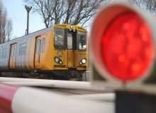

Since the SafeRail project set out in 2013 to assess the feasibility of using satellite technology to improve safety at level crossings, the debate over the dangers posed by locations where rail meets the road has only grown. Many countries are working to phase them out, but the cost of replacing them with new infrastructure is often too high to consider except in the most serious cases.
Go deeper with GlobalData

Even for rail networks with the financial wherewithal to tackle level crossings, such as that of the UK, there are significant complications. The UK’s rail infrastructure manager Network Rail has closed around 900 of its more than 7,000 level crossings since 2010, but its current work to eliminate level crossings in East Anglia to improve train speeds through the region hasn’t been universally popular, with farmers and other residents arguing that closing some crossings outright splits up the community and reduces mobility for some.
Bridges and tunnels are the safest and most favoured response for surrounding populations, but they are disruptive and expensive to build, with the bridge to replace a level crossing at Elsenham – the site of a deadly level crossing collision that claimed the lives of two teenage girls in 2005 – costing upwards of £4m.
SafeRail: milestone reached
Level crossing safety is an old and persistent problem, an unpleasant hangover from an era when rail and road traffic were far slower and less frequent than they are today. SafeRail, a project funded by the European Space Agency, intends to find a new, satellite-enabled approach to improving safety at level crossings in Europe – without breaking the bank.
See Also:
The feasibility study phase of SafeRail, which was carried out by Munich-based systems engineering firm Berner & Mattner, with support from UK satellite data specialist Avanti and Austrian companies Brimatech Services, Joanneum Research and TeleConsult Austria, was brought to a successful conclusion in October 2014.
How well do you really know your competitors?
Access the most comprehensive Company Profiles on the market, powered by GlobalData. Save hours of research. Gain competitive edge.

Thank you!
Your download email will arrive shortly
Not ready to buy yet? Download a free sample
We are confident about the unique quality of our Company Profiles. However, we want you to make the most beneficial decision for your business, so we offer a free sample that you can download by submitting the below form
By GlobalDataFor Rainer Grimm, Berner & Mattner’s head of transportation systems and project manager for SafeRail, the study was an exercise in collaboration. "In this study we needed different knowledge, especially for the navigation and satellite communication," he says. "We don’t have knowledge in all these domains in great detail. We say we are more like an umbrella, bringing all these capabilities together and forming it into one integrated solution. So we were very happy to have these companies onboard, with their expertise, on this project."
Level-crossing safety remains at the top of the global rail industry agenda as a raft of new technologies threaten to make traditional techniques obsolete.
Feasibility study conclusions
The use of satellite technology to continuously track train positions and improve the activation timing of level crossings is in demand in the railway sector, as currently the monitoring of train positions is limited to moments when rolling stock passes particular points along the line.
The ability to track trains continuously via satellite navigations systems, the SafeRail team has concluded, is the key to improving the performance of level crossings. Furthermore, the feasibility study identified that while national main lines usually operate with relatively safe and automated level crossings, secondary and branch lines – which are often stuck with sub-standard crossings that are too expensive to upgrade or replace – have the largest potential to benefit from the new technology.
"As soon as we have this position detection on the train, it will be much easier to activate level crossings," says Grimm. "That means our main conclusion in the study was that this approach would be especially helpful for secondary lines, for example when they upgrade their railway level crossings."
The study also found that a satellite-driven system to operating level crossings would also help solve the issue of expense, as a process dictated by global navigation satellite system (GNSS) and a central command and control system would involve no costly track cabling, while each upgraded crossing would require only local infrastructure as all level crossings in the area would share the same central control centre.
"This means that we have the possibility to do it in a very cost-efficient manner, because you don’t need as much installation on the railway track anymore, like signals and such things," Grimm elaborates. "Now we have a very cost-efficient possibility to upgrade these level crossings."
How does SafeRail work?
Technically speaking, there are few obstacles to getting SafeRail’s vision to work in reality. The Level Crossing Operations (LCOS) system designed during the study is more of an adaptation of existing technology than something entirely new. The system involves several steps: a GNSS receiver installed on a train captures its real-time position and transfers the data to a central command and control system, which would have an interface with level crossings to automatically activate the barrier to cut off car access.
"Then of course we need the interface at the railway level crossing itself, to activate it and also to monitor the status of the level crossing," adds Grimm. "Because we have to feed back this information to the train driver if the railway level crossing has been activated successfully."
The system seems relatively simple, but what is the upshot in terms of improving safety? Given that a large proportion of level crossing collisions are caused by road users losing patience and assuming they’ve got enough time to cross the track before the train arrives, optimising the timing of level crossing barriers could make a significant difference when it comes to tragic human error.
"We don’t have to have these big safety buffers, which are currently used for activating the level crossing because you have to define these buffers by using the highest possible velocity of the train and so on," Grimm says. "As soon as we have a better understanding of when the train will really approach the level crossing, we can close the level crossing later. That means we can reduce the closure times and thus reduce the problem of impatience in car drivers."
Implementing SafeRail’s recommendations
Now that the SafeRail feasibility study has drawn its conclusions and the team has discussed its ideas at conferences in the Netherlands and Italy, the next logical step is obvious – Grimm and his colleagues need to put those ideas into practice. The SafeRail team is looking to leverage the Austrian connections of many of its contractors, and plans to build a prototype of its LCOS system for use by two secondary line operators in the country.
"They [the Austrian rail operators] are very interested in enhancing and updating their level crossings, and we’re just in negotiations with them about how to proceed," says Grimm. "We want to start [in Austria] and prototype a system sometime during the second half of this year. Then we can demonstrate how it really works and how this could be done, and also show it to other customers."
Recent statistics reveal that four of the top ten UK crime hot spots are major railway stations, clear evidence that more needs to be done.
Of course, exposing an idea to real-world operations always brings complications. Building redundancy into such a safety-critical system in case of satellite failure is a vital part of the team’s work. Grimm promises that there will always be a back-up plan. "Our approach is to have a standard operational scenario which does not rely on the satellite data in the first step, but if we are sure we have this data available, then we can enhance the safety at the railway level crossings."
The SafeRail team has also investigated the possibility of using train positional data to inform road users themselves about upcoming level crossings and their status, perhaps via a mobile phone app or telematics. Grimm notes that there are few technological impediments to doing this, but data security issues make it a tricky prospect.
"The obstacle is the availability of the data and the willingness of the [operator to reveal] data of the train’s position," he explains. "As soon as the railway company gives out this data about the position, then they fear to be responsible for this data if there is some accident."
Grimm adds that a compromise such as providing extremely localised data to companies whose employees use a particular street on a daily basis could be more practical. But whatever the outcome of the various evaluations that SafeRail’s satellite system will be subjected to during its demonstrations in Austria, moving from the conceptual to the practical is a key step in bringing a new idea to any market, let alone one as safety-conscious as Europe’s railways. If SafeRail can prove the effectiveness of its system and drive wider adoption of the technology across the continent, it could mark a major turning point for beleaguered operators and, more importantly, for public safety in the railway network’s most dangerous locations.